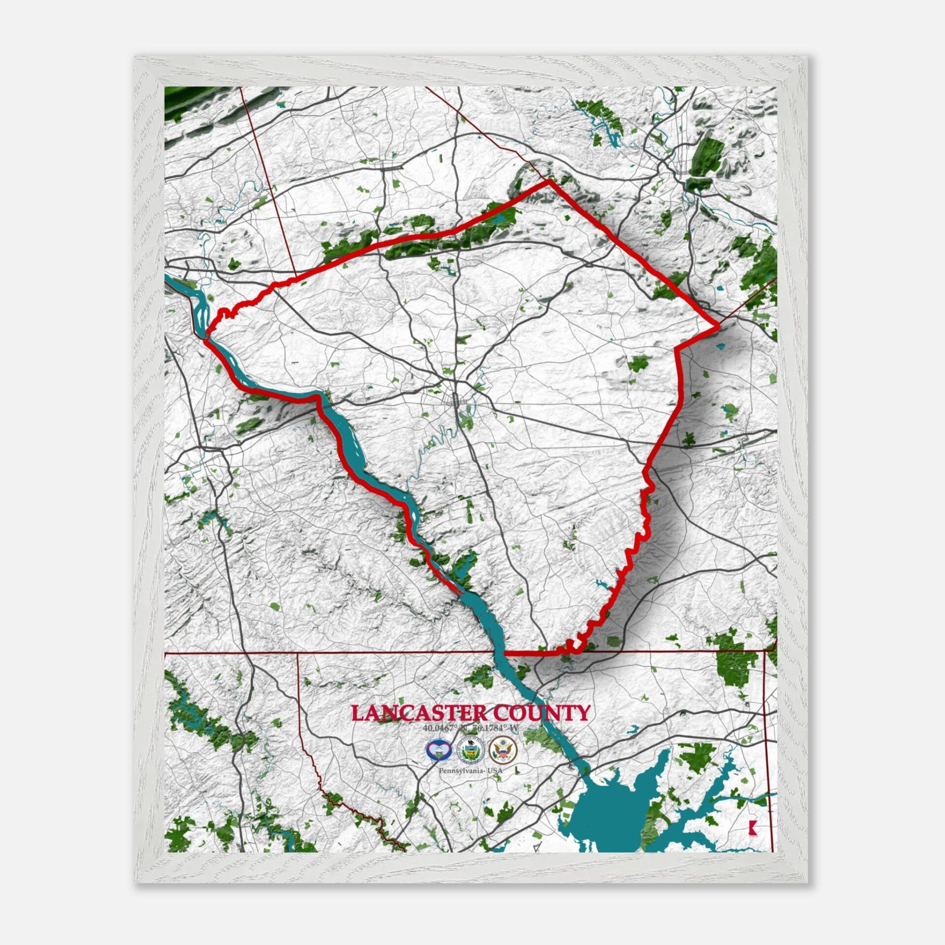
Lancaster County Map: Pennsylvania’s Timeless Map for Your Space
Lancaster County stands as a blend of history, natural beauty, and modern development. Bordered by Dauphin County to the north, Chester County to the east, and York County to the west, Lancaster sits comfortably in a region known for its rolling hills and agricultural roots.
Its location within the United States places it in close proximity to major cities like Philadelphia and Harrisburg, making it a pivotal county in the state’s geographic and economic landscape.
Lancaster County is rich with historical landmarks that speak to its deep roots in American history. Among its most notable sites is the Ephrata Cloister, a religious community founded in the 18th century that still stands as a testament to early American spiritual life.
The Landis Valley Museum is another historic treasure, preserving the rural traditions of the Pennsylvania Dutch. These sites, along with the covered bridges that dot the landscape, offer a glimpse into the county’s past.
Economically, Lancaster County thrives on a balance of agriculture, industry, and tourism. Known for its vast farmlands, the county is one of the top agricultural producers in Pennsylvania, with a strong focus on dairy farming, poultry, and crops like corn and soybeans.
The Amish community plays a key role in this agricultural economy, adding to the county’s uniqueness. Beyond agriculture, manufacturing, particularly in food processing and paper products, contributes significantly to Lancaster’s robust economy.
With a population of around 550,000 people, Lancaster County covers an area of approximately 984 square miles. The county’s blend of rural and urban communities provides a diverse living experience, with larger towns like Lancaster City acting as cultural hubs, while smaller towns maintain a quieter, pastoral charm. This balance between urbanization and rural tranquility is one of the county’s defining characteristics.
Lancaster County’s expansive area and large population make it a fascinating place to explore, and its map serves as a window into its vibrant blend of natural features, roads, and communities. From its rolling farmlands to its historic towns, Lancaster has much to offer both residents and visitors.
Lancaster County: a fascinating place to explore
The roadways of Lancaster County

Linking the towns and cities that make up the region. Major highways like U.S. Route 30, known as the Lincoln Highway, run through the county, providing a direct route from Lancaster City to nearby York County and Chester County.
Interstate 76, part of the Pennsylvania Turnpike, also crosses the northern part of the county, connecting Lancaster to Philadelphia and Harrisburg. Additionally, state routes like Route 222 and Route 283 serve as vital arteries for both local traffic and commuters traveling through the county.
It´s rolling hills, gentle valleys, and fertile plains

Lancaster County’s landscape is predominantly made up of rolling hills, gentle valleys, and fertile plains, making it ideal for agriculture. The county sits on the Piedmont Plateau, characterized by its flat to gently rolling terrain, interspersed with small hills and occasional valleys.
In the southeastern portion of the county, Welsh Mountain stands as one of the few elevated regions, offering scenic views of the surrounding farmlands. The Conestoga River Valley runs through much of the county, providing both a natural and economic backbone to the region’s agriculture.
It´s diverse ecosystems

Lancaster County is home to a variety of natural reserves and green spaces that offer a glimpse into its diverse ecosystems. The Susquehannock State Park, located near the Susquehanna River, is one of the county’s key natural areas, with forests and fields that are home to various wildlife species.
Climatically, Lancaster experiences four distinct seasons, with hot summers and cold winters. The flora includes a variety of deciduous trees, while fauna such as white-tailed deer and wild turkeys can often be spotted in the county’s forests. Temperatures range from an average high of 85°F in summer to lows around 20°F in winter, creating a rich environment for both agriculture and wildlife.
Lancaster County Water Streams

Lancaster County is crisscrossed by rivers and streams that play an important role in the lives of its residents. The mighty Susquehanna River forms the western border of the county, providing water resources and recreational opportunities.
The Conestoga River, which runs through the heart of the county, flows westward into the Susquehanna, serving as a lifeline for Lancaster’s agricultural areas. Numerous smaller streams and creeks, such as Pequea Creek and Chiques Creek, contribute to the county’s water network, supporting both farming irrigation and natural habitats.
Lancaster County Map – PA: A Snapshot of Every Town
| City | Population | Area (sq miles) |
| Lancaster City | 59,265 | 7.4 |
| Manheim Township | 43,988 | 23.1 |
| Ephrata Borough | 13,818 | 3.4 |
| Lititz Borough | 9,510 | 2.3 |
| East Lampeter Township | 16,424 | 20.7 |
| Elizabethtown Borough | 11,545 | 2.6 |
| Millersville Borough | 8,168 | 2.0 |
| … | … | … |
| Lancaster County Total | 550,000 | 984 |
A map of Lancaster County, PA, serves as more than just a geographical tool—it tells the story of a place where history, nature, and community thrive. From the charming townships to the sweeping farmlands, the map highlights the unique blend of urban and rural life.
Whether you’re looking to commemorate a visit, honor your roots, or simply add a touch of local charm to your home, a Lancaster County map is a decorative piece that brings warmth and character to any space. Its detailed illustration of roads, natural landmarks, and towns makes it a beautiful representation of Pennsylvania’s heartland.


